PG&E To Begin North Bay Gas Transmission Pipeline Inspection
News
Benicia CA
23 April, 2021
12:56 PM
Description
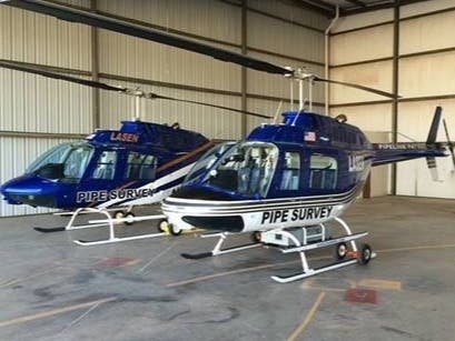
SAN RAFAEL, CA — Pacific Gas and Electric Company will begin conducting aerial surveys of gas transmission pipelines throughout the North Bay beginning Monday with the use of helicopters and other small aircraft, which will be flying as low as 300 to 500 feet, company officials said Friday. The aircraft will be following gas transmission lines in Vallejo, Marin, Napa and Sonoma counties and are part of the monthly aerial patrols of all gas transmission pipelines in the interest of public safety and system integrity, PG&E officials said in a news release on Friday. Beginning Monday, a low-flying Lasen helicopter will inspect transmission lines in the affected counties through the end of April. The pilot will fly to and from San Rafael's Hayward Executive Airport to Sonoma County's Charles M. Schulz county airport. The flights will take place between 8 a.m. and 4 p.m. Monday through Sunday. In addition, pilots in three small airplanes will fly 7,000-9,000 feet above the gas transmission lines between the hours of 8 a.m. and 4 p.m. Monday through Friday. Flights will fly to and from Concord's Buchanan Airfield with possible stops at Novato's Gnoss Field. Using GPS and live video, a pilot and two observers will navigate the pipelines and document excavation and construction activity or other obstructions that could block the right-of-way. Where appropriate, PG&E ground personnel are sent to construction areas to verify that safe digging practices are being followed, the company said in a news release. This includes confirming the use of a valid 811 ticket for proper marking of underground utility lines that help prevent the gas line from being hit. These semi-annual surveys combine the use of LIDAR-based equipment and state-of-the-art leak detection technology to find gas indications, if gas is detected, officials said. PG&E personnel are sent to the field to follow-up. Each patrol consists of a pilot and an observer. The observer in the helicopter also uses a GPS-enabled tablet with mapping data help identify safety concerns that would prohibit access to the pipeline.
Discussion
By posting you agree to the Terms and Privacy Policy.